
Why is the longitude value in the metadata received from DINION 7100i IR in Genetec RSA different than the one from the camera’s WEB page?
Question:
Why is the longitude value in the metadata received from DINION 7100i IR in Genetec RSA different than the one from the camera’s WEB page?
Answer:
The discrepancy is due to the difference in how longitude values are represented in the camera’s web interface (WGS 84 standard) versus the ONVIF metadata stream. WGS 84 uses a range of -180° to +180° for longitude, while ONVIF uses 0° to 360°. Negative longitude values from the camera are converted by adding 360°, which causes the different value in the metadata stream. The camera itself is reporting accurate coordinates, but the metadata system interprets them differently.
Here’s an explanation of the discrepancy:
WGS 84 Coordinate System (Used by Camera):
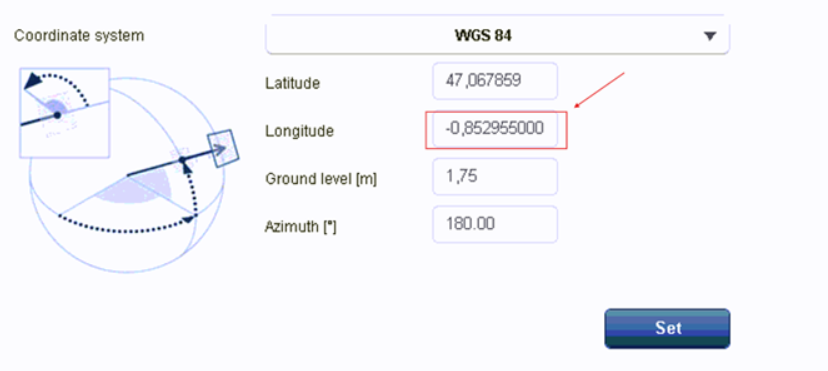
The camera uses the WGS 84 (World Geodetic System 1984) standard, which is the standard for GPS coordinates. The longitude values range from -180° (west of the Prime Meridian) to +180° (east of the Prime Meridian). Therefore, negative longitude values indicate positions west of the Prime Meridian (0° longitude), while positive values indicate positions east.ONVIF Metadata (Used in the Metadata Stream):
ONVIF, the standard used for metadata in video surveillance systems, uses a different format for longitude and latitude. In ONVIF metadata, the longitude values are represented in a range from 0° to 360° instead of -180° to +180°.When a longitude value is negative in the camera's web interface (e.g., -0.852955°), ONVIF will convert it to a value in the 0-360° range. This conversion can be achieved by adding 360° to the negative longitude value, resulting in a positive longitude value that falls within the ONVIF range.
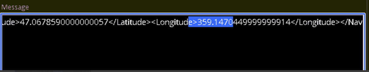
For example, the longitude value of -0.852955° from the camera's web interface would become 359.147045° in the metadata stream (after adding 360°). The metadata stream will show this as 359.1470449999999914, which is very close to the rounded value of 359.147045°.
If you look at the negative value for Longitude in the camera’s web page:
On the metadata, it will be received a different value:
Therefore, there is difference in calculation. That is based on ONVIF Core specifications, available on onvif.org.
To resolve this, it is important to ensure that the metadata stream handling system (such as the Genetec RSA module) is configured to properly account for this transformation between the WGS 84 and ONVIF coordinate systems.